
GPS vehicle monitoring
Speed, location, route, mileage, fuel consumption and much more. Monitoring up to 5000 metrics from each vehicle.
Transport monitoring online for any reporting period
Legal protection of your company interests
Free updates and system customization

- Location, speed and route monitoring. Mileage without markup.
- Fuel economy, eco-driving, driver efficiency ratings
- AETR compliance, tachograph time forecast, DDD remotely
- Refrigerator modes control and temperature telematics of transportation
- Legal maintenance of disputes. Geofencing. Smart cards.
Maintaining a vehicle is always expensive. Including some drivers who are trying to take advantage from your cars. Wind up the odometer, exaggerate the mileage, create fuel ‘surplus’ in the tank, use of the company vehicles for personal purposes, go wild on the road — this is the everyday life of careless drivers.
- Where did your road train park
- How fast the driver was going
- How far did he actually go
- How much fuel was used
- Where did your road train park
- How fast the driver was going
- How far did he actually go
- How much fuel was used
- Which of the couriers are closer to the base
- Did he perform the tasks assigned to him or use working time and fuel resources for personal purposes
How the System
works

Monitor any number of roving workers from one screen
MoreBehind a simple at first sight idea lies a multifunctional assistant that greatly simplifies the work of dispatchers, operators, logisticians and people of other specialties whose duties overlap with those of roving workers.
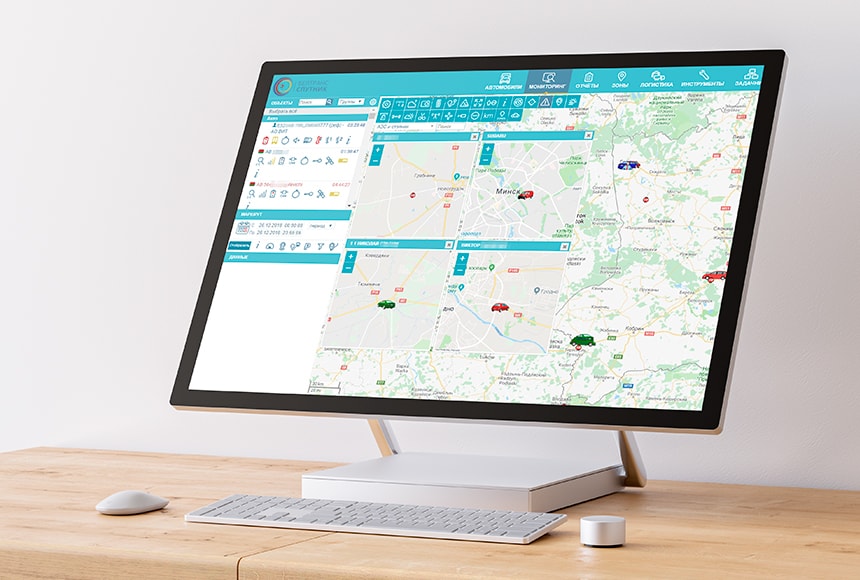
The ability to personalize any vehicle and to track multiple sites at the same time
System versatilityA distinctive feature of the BelTransSputnik Satellite Monitoring System is its versatility. It doesn’t matter if you own your own car park, use third-party vehicles or even use foot couriers: advanced solutions enable you to monitor absolutely any vehicle WITH or WITHOUT intervention in it.

- The module reads data from the vehicle’s systems and, together with the most accurate location data, transmits it via GSM networks to the BelTransSputnik cloud system.
- The system analyzes the data transmitted from the vehicle and displays it on your computer screen.
- The tracker transmits the most accurate data about the location, route and driving style (movement style) of the driver or foot courier to the dispatch computer.
- The program systematizes the data received.
Lifetime warranty on our GPS trackers
*subject to full subscription fee, continuous service from the date of purchase of the equipment and compliance with the operating conditions prescribed in paragraph 5.4 of the Supply Agreement.
Through the system, you also receive data about weather conditions, traffic jams, driving style, etc.
We download all system updates for any of your assignments remotely
What does the solution provide

The system controls the exact location of the vehicle, its speed, operating modes and accurate mileage using GPS/Glonass. Therefore, any additions to the mileage or working hours, which previously led to the accumulation of fuel «surplus» in the tank and unpunished drain, now become impossible.
Without contacting the car, you have access to all the analytics of its condition for any period of time. You can instruct the system to automatically generate significant reports on the operation of your transport, and send it to you in a user-friendly format.
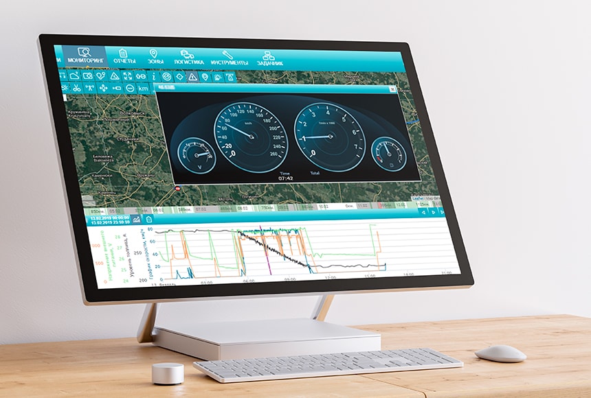
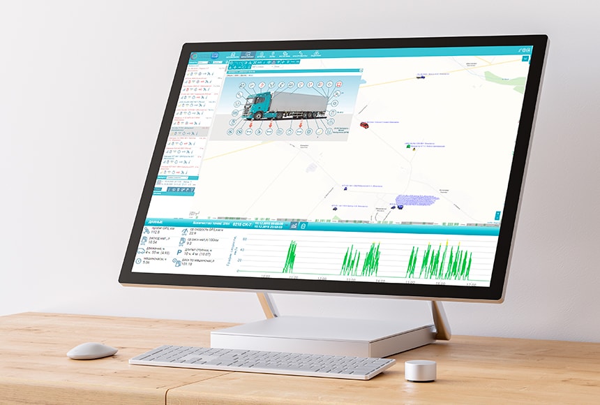
Telemetry tool: we observe changes in the state of the vehicle in any time period.
Tool BenefitsWith the help of the Telemetry tool, you can look at all the main systems of the car through the driver’s eyes! Simply select the desired time interval or route segment, select the metrics you need (speed, rpm/temperature/engine run time, fuel level, battery voltage, etc.) and use the “slider” or automatic player to observe in what condition were they and how did the main metrics of the car change during the period you are interested in.
Benchmark State Navigation Charts
MoreFor 20 years, BelTransSputnik has worked on special procedures and uses benchmark State Navigation Charts. This makes all statements of the System legally significant data.
Any dispute about a route or mileage with a driver, contractor or customer can be resolved objectively and peremptorily, regardless of its limitation period.
Legal defense and justification
MoreOur competence is enough to help you win the court of any instance over any careless employee if necessary. And also, to prove your innocence in litigation with contractors and traffic police.
Legal support is included in our subscription fee. If you have to go to court, we will go with you. For more than 20 years of practice, there has not been a single trial with our participation, which our clients would have lost.
Payback within 1 day
MoreUsing the GPS monitoring system BelTransSputnik enables you to eliminate unnecessary losses and reduce the transportation cost, simplify transport and employee management, get reliable information and detailed analytical reports on all logistics operations. Thus, with proper approach, the payback period of the System is within 1 day.
- location by GPS/Glonass, speed, accurate mileage along the real trajectory
- fuel consumption by all known 7 methods of control
- telemetry of up to 280 vehicle metrics (CAN, OBD II, Kline), including actively requested metrics
- complex machines telematics (construction, agricultural machinery, etc.)
- remote access to tachograph data, AETR time forecast
- temperature telematics (all refrigerator modes, actual and set temperatures)
- car break-in alarm
- control over vehicle and trailer units, anti-theft features
- eco-driving, identification of non-economical driving, aggressive driving, drivers’ rating
- optimal routes planning, considering toll roads and time restrictions
- convenient gas stations planning at profitable gas stations, sludge at safe parking lots
- a wide system of analytical reports on the car park work
- flexible notification system about any significant events with your car
- telemetry of dashboard indications along the entire route
- convenient self-diagnostics of the System: what equipment was disabled by the driver, etc.
- reminders of the imminent maintenance service, repairs, etc.
- displaying traffic jams, weather conditions, EU and EAEU toll roads on the map
- displaying official information of the Ministry of Transport and Communications of the Republic of Belarus on temporary axle load limits on the map
- calculator of all costs for each car (depreciation, maintenance service, repairs, spare parts, etc.) to determine the cost per kilometer and hour of each car
- optimal logistics of goods delivery and customer service, developing optimal routes network considering the forecast of traffic jams on the streets: be on time to all customers for the minimum money or in the minimum time
- automatic detection of schedule deviations
- electronic waybills: automatic and manual
- sending assignments and routes to drivers’ smartphones
- remote workflow between the driver and your office
- map matching: the ability to ‘pull’ the GPS trajectory of the car to the axis of the road to eliminate disputes over mileage between the contractor and the customer
- geofencing: automatic notification about a vehicle deviation from a given traffic corridor
- finding the nearest cars to a given point
- the ability to identify GPS, GSM jammers
- location determination by GSM towers (LBS) in case the driver pulled out the GPS / GLONASS antenna or during the GPS / GLONASS jammers action
- information security: login, password, IP, multi-factor identification, the client manages data storage — from 1 hour to 10 years
In what scopes the System is required

- Domestic transportation
- International transportation
- food delivery networks
- Online stores
- Trade and merchandising
- Courier Services
- Delivery services with foot couriers
- Construction
- Emergency Services
- Agricultural industry
- Taxi, car rental, carsharing
- Housing and communal services
- Production
Our customers result

After the implementation of the GPS monitoring system, we immediately felt the result:
- fuel costs have reduced significantly
- several large fuel thefts have been prevented
- got a real opportunity to write off fuel on the fact
- for now, 99% of fuel draining issues at the factory are excluded.
Now we are adding units of equipment, and we are spending the same amount of money for the fuel purchase.

We have been cooperating with BelTransSputnik since 2010. And during this time, we have implemented many solutions that have been customized specifically for us — this is particularly nice. Definitely, BelTransSputnik’s solutions help to optimize business processes and have a positive effect on customers’ loyalty.
- first investments paid off immediately and repeatedly.
- customers loyalty increasing by introducing courier tracking — customers can track the arrival time and the movement of the courier on the map.
- integration with current ACS was set up.

The GPS monitoring system can also help in unforeseen situations. For example, there was a case in Poland. The driver started the car and was about to move out of the parking lot — but felt a blow to the rear bumper. He quickly got out of the cab to find out what was the matter, forgetting to remove the key from the ignition. While he reached the back of the car, a thief got into the cab, faked a blow to the rear bumper, got behind the wheel and drove away. Thanks to the BelTransSputnik tracking system, the police managed to find the van quickly. They started chasing the thieves. They heard the siren and left our van.
Another example. Rarely, a car can break down on the road. And if this happens on the way to the client, the dispatchers monitor all the nearest vehicles in the area. And we automatically see which vehicles are closer, which ones need to arrive urgently and make a cargo transfer.
Here are some results from the system implementation.
- Fuel consumption rates reduced by 16%.
- The average traffic speed of a vehicle, taking into account loading and unloading operations, has increased from 50 km per hour to 65 km per hour. The rate of supply of high-quality raw materials to the factory has increased.
- Logistics department was optimized to 4 persons. Without the system, we would need another 1-2 employees.
- Driver discipline has improved.
We are pleased with the service and the attention we provided: preventive visits, trainings, audits and repairs with a swing space at any time and much more.
Now we are working on the system to help make management decisions. Speaking about results achieved:
- Manageability has improved: now it is more realistic to predict the plan that will be executed.
- Prevention of the use of company vehicles for personal purposes has brought a positive result.
- Expenses reduced. We see how many kilometers the employee has passed, how much time he spent with the client.
- Driver discipline has improved.
The system helps in unforeseen situations. Now if our driver in Germany has a problem, we will know about it and we will help.
Working principles


Automate transport control and start saving up to 60%
of your transport expenses with the help of GPS vehicle monitoring